What is known about our marine neighbourhood
The currents of knowledge in our oceans
The Waiheke Marine Project is dedicated to fostering evidence-based, place-based learning to reveal and amplify the many currents of ecological knowledge and wisdom available to us when it comes to knowing, monitoring and protecting our marine environment.
Just as the ocean itself, knowledge exists as several currents; be they the currents that bring generationally-informed mātauranga Māori (Māori wisdom and knowledge), western scientific insight, or every day citizen observations to shore. Each current works symbiotically to carry in tides of invaluable information, validated through relational worldviews that inform, enliven and deepen our connection to and understanding of our role as agents of regeneration in Tīkapa Moana/Moananui o Toi/the Hauraki Gulf.
As a place-based kaupapa that is committed to walking the path of Te Tiriti partnership and processes of restorative ecological healing, the Waiheke Marine Project sees learning and knowledge production as a lively ecosystem of relationships. This means that we are consistently working to ensure that each knowledge current is acknowledged, protected and advocated for in contextually relevant ways for the benefit of the environment, the people and the future generations to come on Waiheke/Te Motu Arai Roa. Mātauranga Māori and western science, from this view, are both vital knowledge-driven methodological disciplines that build upon inquiry, hypothesis, and testing through experimental observation. In contrast, citizen observations are based on personal observations collected in a casual or non-systematic manner, although still contribute deeply to contemporary understandings of environmental change and ongoing regenerative action. Together, these three knowledge currents converge to turn the tide toward enduring tino rangatiratanga and kaitiakitanga for mana whenua of Waiheke, ngā uri o Ngāti Pāoa, as agreed to under Te Tiriti o Waitangi, as well as deepening place-informed engagement for local Waiheke community members who find themselves settled here as tangata tiriti in more recent generations.
Gathering knowledge about our oceans is, however, a complex and contested terrain. There is an enormous amount of scientific research available on the Hauraki Gulf, and in particular we would point towards the State of the Gulf reports produced every three years by the Hauraki Gulf Forum. Additionally, there have been several other studies commissioned to determine the state of our oceans, although many of these are inaccessible by virtue of various institutional barriers at either the university or governmental level. It is therefore the aim of the Waiheke Marine Project to access and bring together scientific baseline information and analyses that pertain to Waiheke as an ecosystem with its own specific opportunities and threats that are unique to place. Additionally, given the ongoing effects of systemic colonialism within institutional knowledge spaces, mātauranga Māori pertaining to Waiheke has, for the most part, been safe-guarded within emplaced hapū across the larger Ngāti Pāoa rohe to date. The process of gathering and applying mātauranga is therefore a slow and emergent process of collaborative learning, deep listening, and respectful reciprocity between mana whenua and tangata tiriti. We are currently working on ways to best ensure the safety and longevity of mātauranga Māori from a NPKW perspective in order to actively redress ongoing issues of epistemic injustice and erasure in Waiheke’s knowledge land/seascape. Citizen science and observations will be tracked on our emergent ‘action-tracker’ that link to details of all our findings, from our kororā sighting, and evidence of our kōura placings around the motu.
(Please note: these will not be specific locations but observed evidence of local community and mana whenua sightings.
Working through the trial ‘action tracker’, it has been found to be a perfect tool to research, collect and retain knowledge of journeys, history and pūrakau from mana whenua (through primary sources) with a realisation of the possibility to build in footage of local observations to our everchanging environment and noting the distinct behaviour of the local fauna.
In this section, we have attempted to pull out some of the interesting data and discussion from these studies, and added some references for those of you who want to dig deeper and really get to know a subject.
Please let us know if you have found any interesting research that you would like to make us aware of.

Habitats
This high level habitat map of Waiheke Island’s marine environments was created in 2020, using SeaSketch. View the Waiheke habitat map here
A survey of Waiheke marine habitats by Kerr & Grace was carried out in 2013. The north coast of Waiheke Island was mapped using single and side scan sonar, underwater video and still photography. The full 35 page survey report can be downloaded here.
The resource below was produced by Waiheke Marine Project with imagery and information directly from this survey.
Sedimentation
Report after report tells us that we are seeing the habitat of all of our ocean species being degraded. There are a number of factors for this, mainly driven by human habitation and increasing population numbers:
habitat destruction - through trawling, smothering from sedimentation and dredging and dumping
run-off or sedimentation - from farming (particularly dairy intensification), forestry, coastal development, poor sewage disposal and from the ever increasing amount of concrete and tarmac over our major city and its surrounds;
other pollution – also from human habitation, eg from littering, poor industrial and farm working practices, aquaculture, and increasing amounts of plastic ending up in the sea, including pre-production pellets (or nurdles);
climate change - heating up of the oceans and ocean acidification, and the associated impact on plant and animal species.
Pollution
A key habitat stressor is Pollution. We are all aware of the damage done to the Hauraki Gulf through dumping or accidental release of toxic chemicals (e.g. copper can leach from brake pads, old tech anti-fouling paints on boat hulls, and zinc from rusty roofs), plus marine litter, including plastic pollution.
Read article: http://www.nzherald.co.nz/environment/news/article.cfm?c_id=39&objectid=10744343
Some good work is being done to minimise or reverse these trends, such as GulfX - a new project, run by the Sustainable Business Network, aiming to stop pollution caused by heavy metals flowing into the water from the land.
See link for more detail (and includes positive action suggestions for individuals): https://sustainable.org.nz/gulfx/
You can read more information from the State of the Gulf report (2020).
Ecosystems
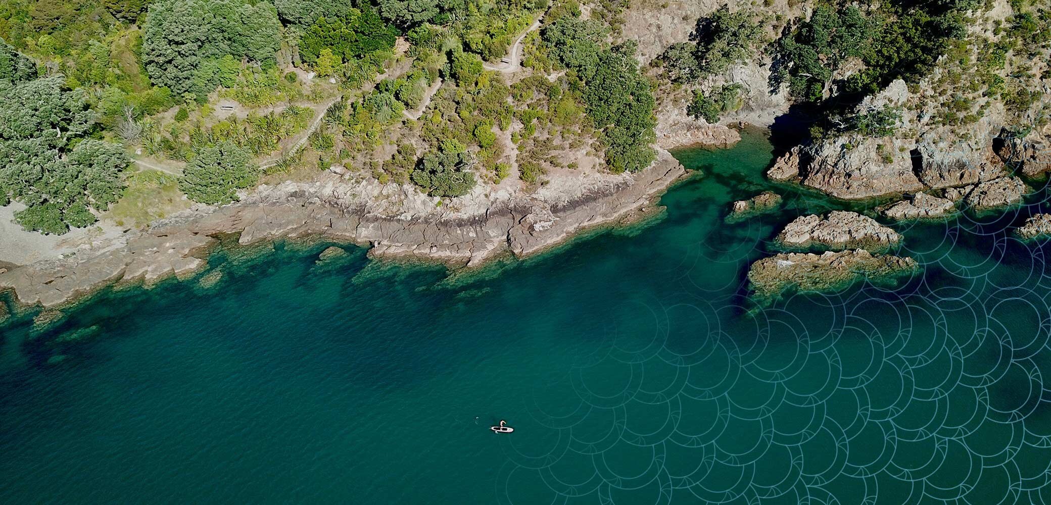
Waiheke Island is situated in the centre of the Hauraki Gulf (Tīkapa Moana) and has 133.5km of coastline, made up of numerous different ecosystem types and occupied by a diversity of wildlife.
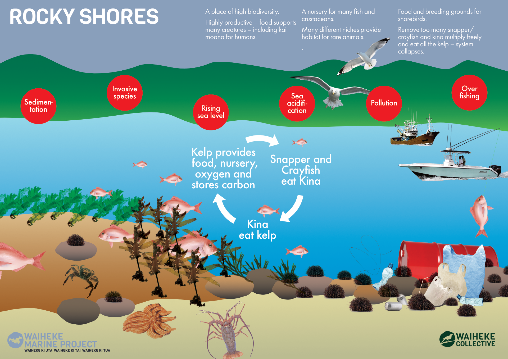
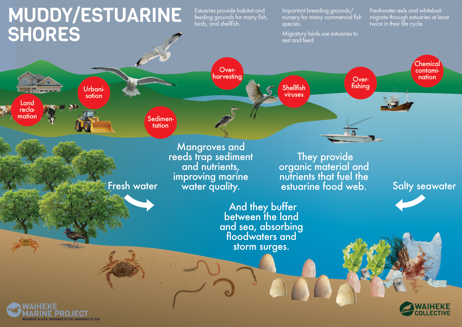
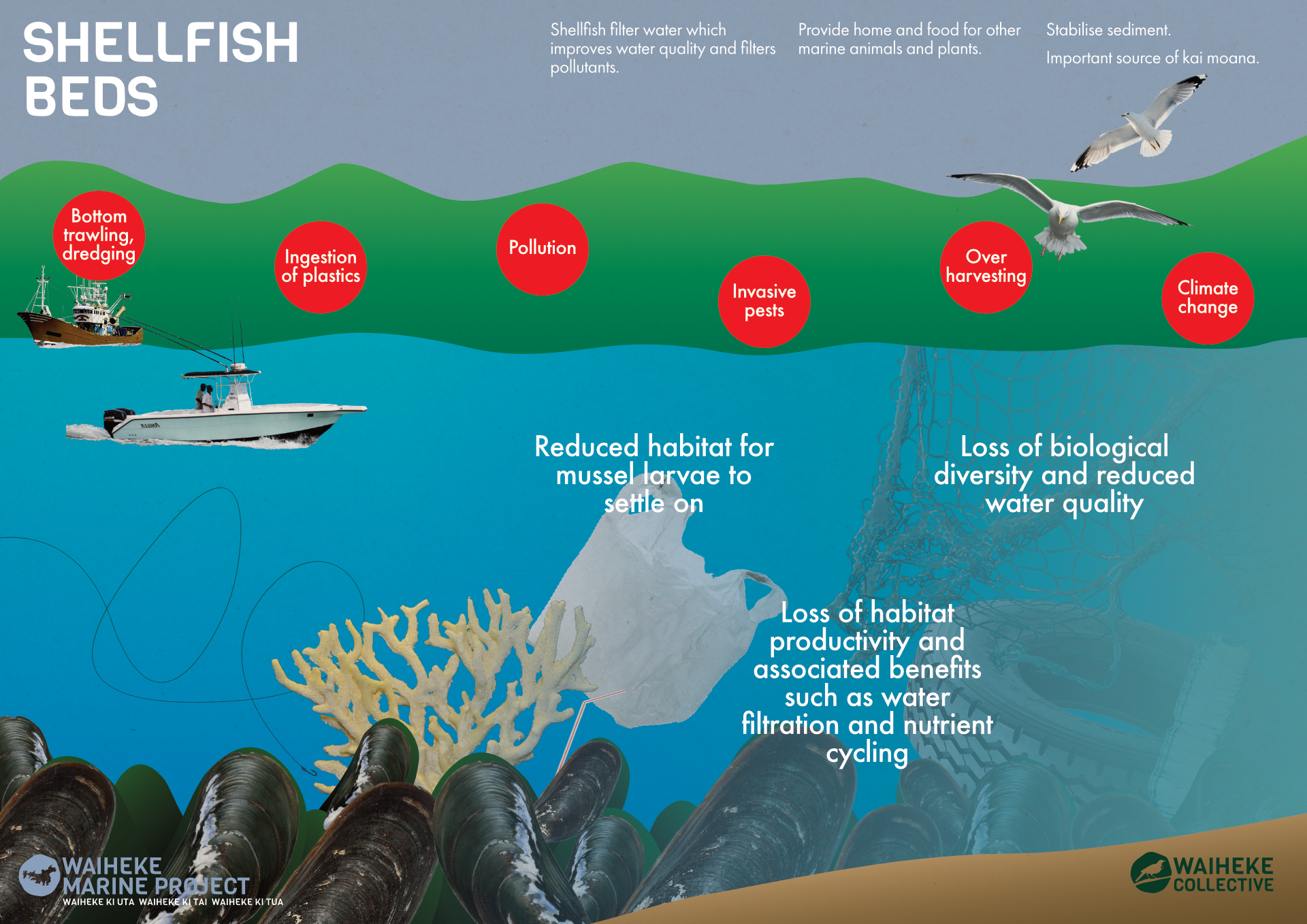
The Waiheke coast is made up of Rocky Shores, Sandy Shores, Muddy/Estuarine Shores, Mangroves, SeaGrass and Salt Marshes to name a few. With such diversity these ecotypes face different pressures and therefore require different tools for protection and regeneration. The Waiheke Marine Project is nurturing engagement from a diverse set of voices as to truly understand the challenges these different eco types face and the best collaborative actions to protect and enhance them.
These ecotypes and factors influencing them are illustrated below.

Marine Life - Overview
The Department of Conservation outlines that our rich and complex marine environment ranges from subtropical to subantarctic and contains over 15,000 known species. These include corals, anemones, jellyfish, crabs, crayfish and other crustaceans and shellfish, starfish, sea urchins, sharks, rays, seals, whales, dolphins and other marine mammals, octopus and squid, plankton, and seaweed.
“Marine environment” refers to New Zealand’s Territorial Sea (from the shore out to 12 nautical miles) and Exclusive Economic Zone (from 12 nautical miles to 200 nautical miles from the shore).
More from the Department of Conservation can be found here:
https://www.doc.govt.nz/nature/habitats/marine/new-zealands-marine-environment/
In the next section, we will take a look at fish, sea- and shore-birds and marine mammals.
Marine Life - Fish Populations
There are hundreds of saltwater fish species found in NZ’s waters, yet you would be hard pressed to find many people who could name more than 20 or so. The “iconic” species of snapper, kahawai, kingfish, gurnard, terakihi, and trevally dominate popular consciousness.
Fishing plays an important part in the lives of many New Zealanders. Not only do fish provide kai, the experience of being on or by the water and connecting with nature contributes to our wellbeing.
Snapper (tāmure) is New Zealand's most popular recreational fish species and Kahawai are the second most commonly caught fish in New Zealand. Blue Cod (rawaru - primarily found in the South Island) and Kingfish (kahu) are particularly popular too.
Given that many of the changes in the Hauraki Gulf have been associated with fishing, we need to be aware of the facts and the scientific evidence for trends. Here we summarise some of the findings from the 2020 Fisheries Assessment Plenary from Fisheries New Zealand2 and the 2020 State of Our Gulf report1, focusing on Snapper.
Fish populations and their age structure are estimated by models using data from commercial catch reports, surveys of recreational catch and tracking tagged fish, including species, number, age, length and weight. These models focus on individual species, viewed as commercial fish stocks, and are designed to inform estimates of allowable catch in order to set quotas at sustainable levels. Thus data for the total number of fish in the Gulf are more difficult to find.
We do know that overall commercial fishing in the Hauraki Gulf has increased by more than 20% in the last 20 years. In 1996-99, the commercial catch was 42% snapper. However, in 2016-19, snapper only made up 23% of the commercial catch (Blue mackerel 36%, Jack mackerel 10%, Other species 31%). Nowadays, more snapper are caught by recreational fishers than by commercial boats.
The Baseline Stock (B0) is an estimate of the ‘unfished’ biomass of a particular species, around the year 1900. Because different species have differing resilience to fishing, the Maximum Sustainable Yield (MSY) varies by species. For a low productivity species with a high age of maturity, high longevity, slow growth rates or low fecundity (e.g. snapper), MSY is set at 40% B0, which is known as the ‘management target’. The ‘soft limit’, below which a population is considered to be ‘overfished’ is 20% B0, while stocks below 10% B0 are considered to be “collapsed”.
Snapper stocks in the Gulf are estimated to have been below 40% of the ‘unfished’ level (40% is the current management target) since the 1970s, reaching their lowest levels in the 1990s. Over the last decade, levels have recovered somewhat, likely due to the raising of the minimum length and lowering bag size for recreational fishers, as well as the lowering of commercial quota catch limits in 1997. However, stocks are still dangerously low.
Even though populations of snapper in the Gulf have been estimated to be fairly stable in the last decade, the recreational catch of snapper has been rising quite sharply, from an estimated 900 tonnes in 1991 to over 2,500 tonnes in 2012. Fisheries NZ suggest that this is likely due to a 50% rise in catch efficiency. As you can see in the graph above, snapper are back in the “overfished” category.
There are many sections on fishing, fish stock sustainability, and notes on certain other notable species, in the 2020 SOTG report, and we urge you to read them.

Marine Life - Fishing methods and best practice
Both commercial and recreational fishing methods have impacts to the species being caught and the environment in which they are fished from. However, the level of impact varies depending on the methods used. These impacts include bycatch, ghost fishing, habitat destruction and pollution.
Here is a summary of the types of fishing methods used and their relative impact:
This has been adapted from Forest & Bird, 2012 and MPI Recreational Fishing Survey, 2019
Bycatch is the result of unintentionally catching other species, including sea birds, whilst targeting a certain type and size of fish, as well as catching under-sized, juvenile fish of the target species.
Commercial fishing methods that have a high bycatch rate include:
Long-lining, gill-netting, seining and trawling.
* The survival rate of fish returned to sea, either for catch and release fishing, or because they are under-sized, is dependent on many factors including the skill of the angler. The primary factor is the depth at which the fish is caught, but there are other considerations such as use of circle vs J hooks and barbed vs barbless hooks, plus the level of stress and exhaustion of the fish and time out of the water before release.

Marine Life - Mammals
One of the unique whale species found in Tīkapa Moana is Te Pakake (Bryde’s whales). While its conservation status is Nationally Critical and concerns remain about reduction in its prey as a result of recreational and commercial fishing, ship strike deaths have reduced since 2013. This is the year a voluntary transit protocol was introduced to limit ship speeds. Kāhahi (Orca) pods from New Zealand’s small coastal population are regular visitors to Tīkapa Moana. Because of the small size of the New Zealand orca population, it is an ‘at risk’ species. Aotea (Great Barrier Island) appears to be a strong-hold for Terehu (the northern NZ bottlenose dolphin). Aihe (Common Dolphin) is frequently seen in Tīkapa Moana and visiting Waiheke bays. All marine mammals face similar threats which include boat strike, pollution, adverse impact, entanglement, shootings and loss of prey species due to human activities such as fishing.
Interesting links;
Conservation status of New Zealand marine mammals, 2019 report
https://www.orcaresearch.org/wp-content/uploads/2011/08/Visser-2000-orca-NZ-PhD-Thesis.pdf
ICONS OF THE GULF NGĀ MANATUNGA O TĪKAPA MOANA / TE MOANA-NUI-A-TOI
Seabirds and Shorebirds
Tikapa moana (Hauraki Gulf) has always been rich in sea and shore birds (ngā manu o te moana/nga manu o tātahi). Many features in Tikapa moana are named after our birds e.g. Gannet Rock (Horuhoru Rock). Waiheke Island has always had colonies of kororā (little blue penguin) which is the world’s smallest penguin and ōi (grey-faced petrel) nests are found on our coast. Other special sea and shore birds found in Tikapa moana include tūturiwhatu (northern NZ dotterel, tāiko (black petrels), tara iti (fairy tern) and takahikare-moana (storm petrel). Tīkapa moana is, also visited by migratory birds such as kuaka (bar-tailed godwit) who summer feed in its estuaries and mudflats.
There has been a disturbing decline in our sea and shore birds over several decades. This decline is an important indicator of the overall poor health of Tīkapa moana. In 2000, 4% of our seabirds were classified as Threatened, today 22% are and more of our shorebirds are Threatened (3 species in 2000 and 5 in 2020). Some species have benefited from active shore-bird management e.g. tutiriwhatu and torea-pango (variable oystercatchers). Threats to all these birds include fishing methods, pollution (including plastic, oil spills, noise and artificial night light), predation by both introduced pests (stoats, rats) and domestic pets, habitat loss caused by human activities, marine-related threats such as boat strike, net and plastic entanglement and competition from fisheries for species they eat. New invasive species affect food supplies. Climate change may also increase disease mortality.
Community Attitude Survey
In 2015 Colmar Brunton conducted a Survey of ‘Attitudes towards Marine Protection’ on Waiheke Island. There were 1999 responses from registered resident voters and off-island ratepayers - this is about 20 odd % of the community and of those we can see how many support some form of marine protection.
Marine Reserve study
In 2016, the Waiheke Local board in association with the Hauraki Gulf Conservation Trust engaged Ecoast Consultants of Raglan, to provide a feasibility study and a gap analysis. Tim Haggitt was given five predetermined areas to report on which were named PMR’s or proposed no take marine reserves. Whilst the report was able to pull on summary ecological datasets from Seasketch 2016, unpublished Auckland Council remote sensing data, technical reports and scientific studies it identified gaps in existing quantitative data. Dr. Haggitt commented that “Moving forward it will be important that the marine reserve network development for Waiheke Island is an inclusive process…”
Marine Reserve Ecological survey
Later in 2016 following on from the outcomes of the gap analysis Tim Haggitt conducted a first-order subtidal ecological survey of the north-western region of the Waiheke Island coastline within the previously selected areas. Tim comments ‘while all reserves had some conservation merit, further data gathering was necessary in order to better document and understand the habitats and species within the proposed reserves. The report details the results of quantitative benthic rocky reef sampling, reef fish sampling, and qualitative soft sediment sampling.
A new paper to consider
“Small marine reserves do not provide a safeguard against overfishing”
.by Diana LaScala‐Gruenewald, Roger Grace, Tim Haggitt, Benjamin Hanns, Shane Kelly, Alison MacDiarmid, and Nick Shears published in Febraury 2021
Additional Marine Reserve reading
Ballantine, B. (2014).
Fifty years on: Lessons from marine reserves in New Zealand and principles for a worldwide network. Biological Conservation, 176, 297–307.
No-take marine reserves are the most effective protected areas in the ocean.
ICES Journal of Marine Science, 75.
Scientific and biodiversity values of marine reserves:
A review in 2013 - 74 pages;
https://www.doc.govt.nz/globalassets/documents/science-and-technical/drds340print.pdf
This report contains a useful bibliography of previous articles on marine reserves in NZ.
References & our sources
1. Sedimentation
Assessment of anthropogenic threats to New Zealand marine habitats. Wellington, New Zealand: Ministry of Agriculture and Forestry; 2012.MacDiarmid A, McKenzie A, Sturman J, Beaumont J, Mikaloff-Fletcher S, Dunne J.
Summary of historic estuarine sedimentation measurements in the Waikato region and formulation of a historic baseline.Hamilton, New Zealand: Waikato Regional Council; 2019.
Hunt S.
Sediment deposition in the central Hauraki Gulf, New Zealand
Boxberg et al, 2019
NIWA freshwater and estuaries – From land to sea, tracing our trash. Article here
Water quality and sources of nitrogen and phosphorus in the Hauraki rivers, 2006–15. Hamilton: Waikato Regional Council;2016.
Vant B.
2. Pollution
Microplastic contamination in Auckland (New Zealand) beach sediments
Bridson et al, 2020
3. Marine Life
State of Our Gulf 2020, p29, Hauraki Gulf Forum.
Fisheries New Zealand (2020). Fisheries Assessment Plenary, May 2020 p 1435-6
Biomass graph - State of Our Gulf 2020, pg 51 Hauraki Gulf Forum
Fishing methods - Specific Fishing Methods • Environment Guide & National survey of recreational fishers | Fisheries NZ | NZ Government
4. Seabirds & Shorebirds
Whitehead E, Adams N, Baird KA, et al. Threats to seabirds of northern Aotearoa New Zealand. Auckland, New Zealand: Northern New Zealand Seabird Charitable Trust; 2019.